RNAV/GPS Approach Procedure
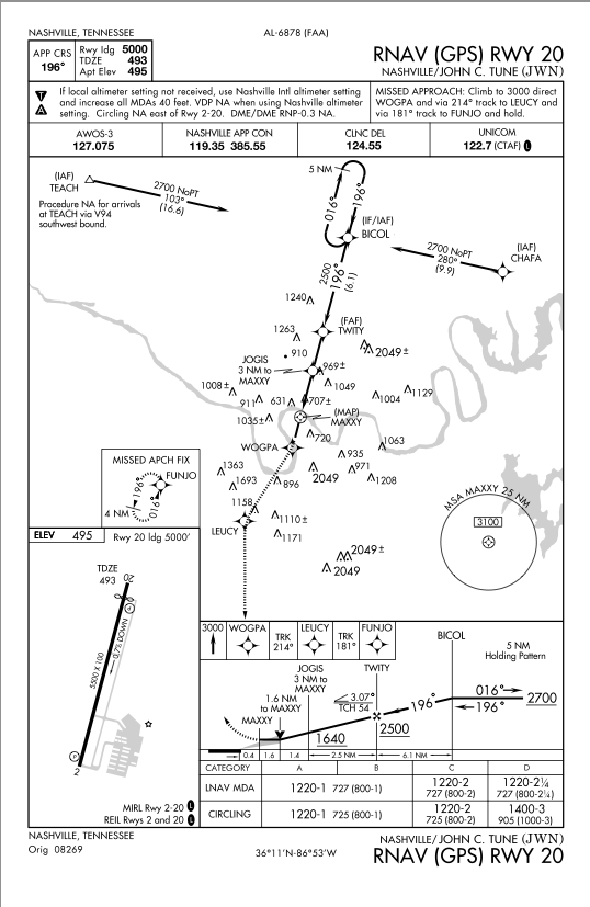
Let's now discuss RNAV/GPS approach procedures. Here is the approach we will study. Please note that this approach chart is expired. Also note that some fix names have been changed to match the Garmin 430 simulator, and the actual approach may have different names for some or all of the fixes.
To fly a GPS approach, you must have an approved, IFR certified GPS receiver installed in the aircraft. A portable GPS system is not an approved system. The most common GPS receivers today are the Garmin 530, 430, and G1000. We will look at flying this approach with a Garmin 430, though the 530 and G1000 setups for a GPS approach are very similar.
For the purposes of this discussion, let's assume we are coming from the Smyrna airport (KMQY) and are currently southeast of the CHAFA waypoint.
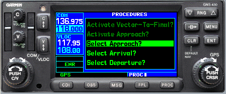
First, we have to tell the Garmin 430 what approach we want. Assuming that we already have our destination airport in the flight plan, we simply hit the Proc button to bring up the following menu.
Use the right hand outer knob to select Select Approach? then hit the ENT button.
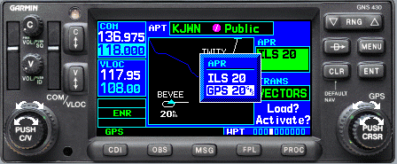
To select the approach you want, again use the right hand outer knob and select GPS 20 and hit ENT again.
Now the 430 is asking what initial approach fix we want. Are we receiving vectors to final from ATC, or do we want an initial approach fix from the chart? In this case, we want to select CHAFA because we are closest to it and it will require less turning to intercept the final approach course than any other initial fix. Choosing the closest IAF on a TAA (terminal arrival area) approach will also ensure obstacle clearance.
Use the right hand outer knob to select CHAFA and hit ENT again.
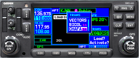
Finally the 430 asks us if we want to Load or Activate the approach. My rule of thumb is that if I'm either receiving vectors or cleared to the initial fix of my choice, I will Activate it. Otherwise, I will just Load the approach and activate later. The reason is that once I activate the approach, it loads the IAF I selected as the next waypoint in my flightplan. If I haven't yet been cleared for the approach, or if I'm not yet ready to head to the IAF, that is likely not the desired result.

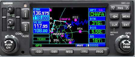
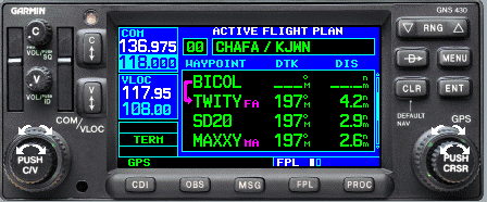
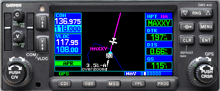
So here we are. Southeast of CHAFA just as we expected. The fields on the right are:
- WPT - next waypoint (CHAFA)
- DTK - desired track of 316° to our next waypoint
- DIS - distance - 5.59nm
- GS - groundspeed (ignore this value in these pages, it will be meaningless)
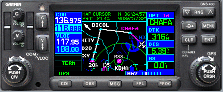
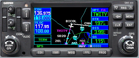
Here is another shot after zooming in with the left RNG button at the top right.
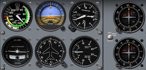
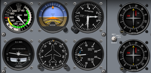
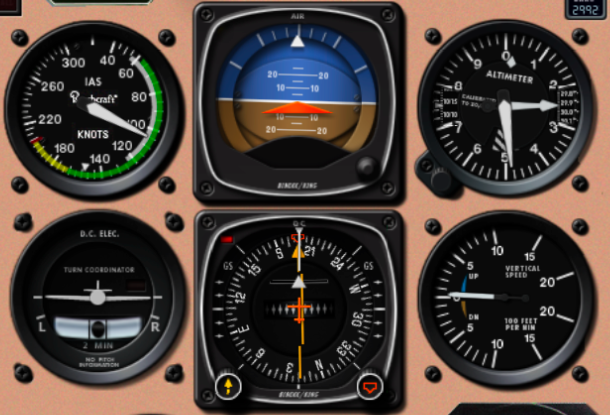
And here is what our panel should show (approximately) at this point.
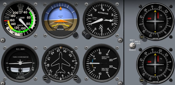
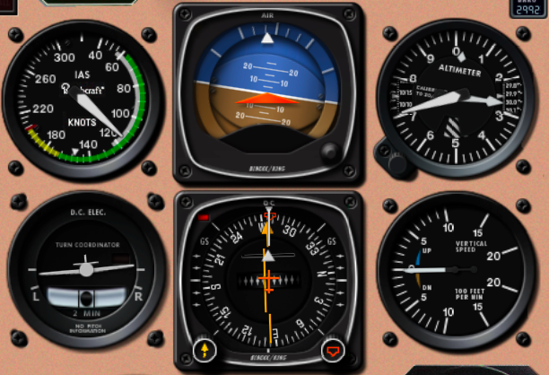
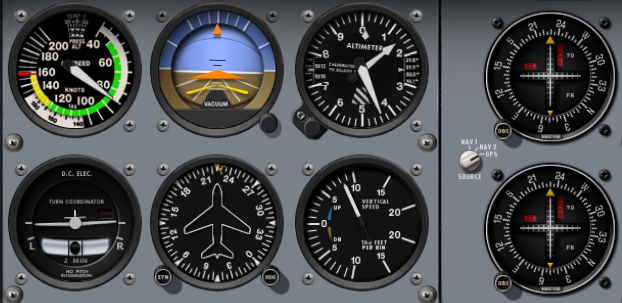
Here we are at 2700 feet as the chart calls for at CHAFA in a simulated 172.
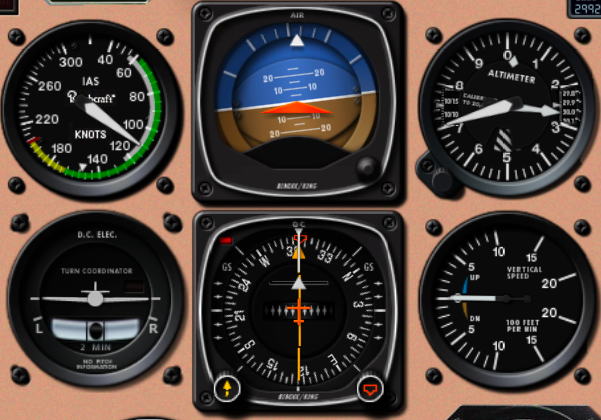
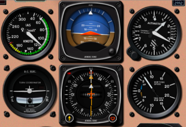
Here we are, at the same spot, in a simulated Bonanza with an HSI rather than an OBS.
Upon reaching CHAFA, the approach chart directs us to turn to 280° and our Garmin matches that for the DTK to our next waypoint of BICOL.
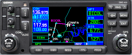
And here is our 172 panel as we finish up the turn and are intercepting the course of 280° after passing CHAFA.
And in our Bonanza...
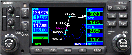
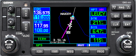
As we approach the BICOL waypoint, we start a left turn to the final approach course of 196° and begin a descent to 2500 feet MSL as called for on the approach plate. Note that BICOL is a fly-by waypoint, rather than a fly-over, so we lead the turn to the final approach course. The Garmin will give us a heads up on the turn by flashing "Next course 196°" and counting down to the start of our turn.
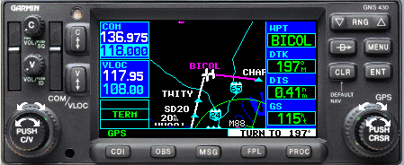
If you look at the "Flight Plan" page by pressing the FPL button, you will see that the activate leg of this approach is BICOL to TWITY, just as we expect.
You can hit the FPL button again to exit the "Flight Plan" screen. Here we are just past BICOL on our way to TWITY
This is an important point in the approach. We are within 2nm of TWITY. Look in the lower left corner of our 430 screen below - see where it says APR highlighted in green? That signals to us that the 430 is now in "Approach" sensitivity. On a GPS approach, you want to always make sure you get that indication within 2nm of the FAF. If you don't, there is a problem and you need to abandon the approach by immediately executing the missed approach instructions. This may indicate a problem with RAIM (receiver autonomous integrity monitoring), the GPS resolution, or the approach set up on your GPS receiver.
According to the Garmin 430 manual, here are the three CDI sensitivities and their meanings:
| Sensitivity | Description |
|---|---|
| Enroute | Outside 30 nm from destination airport, CDI full deflection is 5nm (10nm from one side to the other) |
| Terminal | Within 30 nm of destination airport, CDI full deflection is 1.0 nm |
| Approach | 2 nm from FAF, full deflection is 0.3nm |
As you can see, the CDI becomes much more sensitive during approach mode. That's why it's imperative that you check for the change from "Term" (terminal) to "APR" as you approach the FAF.
Here's our 172 panel as we level out at 2500 feet on our final approach course, still motoring towards TWITY. During this intermediate leg, you should also prepare the airplane for landing via checklist or GUMPS. You certainly want to be ready to land before reaching the FAF as things get busy after that.
The Bonanza panel...
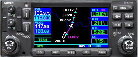
Now we've passed TWITY and our next waypoint is JOGIS according to both the chart and our 430. JOGIS is what we refer to as a step-down waypoint, meaning there is an altitude step-down between the FAF and the MDA of this approach. We begin a descent to 1640 based on the information in the profile section of the chart, maintaining our final approach course of 196°
After passing JOGIS, we will descend to our approach minimums of 1220 feet MSL. If we do not yet have the runway environment in sight, maintain 1220 or above and continue until the missed approach waypoint.
Ok, let's assume we never saw the runway, so it's time to execute a missed approach after passing the MAP.
As you cross the MAP, "SUSP" will appear above OBS key indicating that auto sequencing will be suspended at the MAP. Now that we are executing the missed approach, press the OBS key to tell the 430 to initiate the missed approach sequence.
The OBS key has two functions on the Garmin 430/530 series GPS receivers:
1. Toggle SUSP mode during the final portion of an approach. In this case, we use it to deactivate SUSP so that the receiver will sequence us to the MAP.
2. Allow the input of an arbitrary course to be selected by the pilot using the OBS or CDI, and display that course on the receiver.
Initiate a climb, turn to maintain the 211° DTK for the first waypoint on the missed approach, WOGPA, then to LEUCY. Upon reaching LEUCY, turn to 181° to FUNJO then initiate a parallel hold entry, evaluate your options and decide whether or not to shoot this approach again.
Bonanza panel below.
Common Mistakes
- Improper wind correction
- Failure to note APR sensitivity 2nm from the FAF
- Failure to press the OBS key to deactivate SUSP mode and initiate the missed approach sequence
- Failure to recognize step down fixes
- Going below minimums
- Selecting the wrong minimums for the airplane category
ACS Test Standards
- Altitude +/- 100 feet
- Heading +/- 5°
- Airspeed +/- 10 knots
- CDI within 3/4 scale deflection