Low IFR Enroute Charts
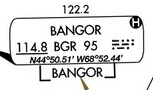
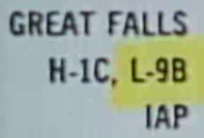
Low Enroute IFR charts cover airspace from surface to FL180. You can find which low altitude chart is used in the AFD at the departure airport - upper right corner (eg "L-9B") (GREAT FALLS sectional and H-1C high alt chart):
Better still, go to either VFRMAP.com or SkyVector.com
Airspace Depictions
- Class B - identified by box with "Class B" and blue circle with solid thin line
- Class C - again, blue shaded but with dashed line around it, "C" in square next to airport name
- Class D - shaded white, looks like a clock
- Class E - white space on either side of airways
Class B:
Class C:
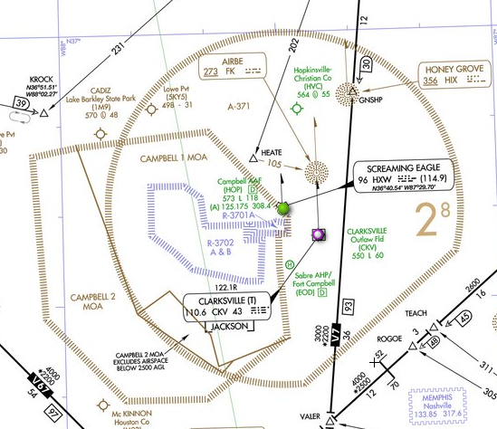
Special Use - Military Airspace
Restricted areas - blue outline, hazardous activity, live weapons, etc
MOA - military operations area - outlined in brown, less hazardous, usually training, no live weapons. Used to separate IFR traffic from military training. You don't have to worry if MOA is on your route, ATC will route you around or through depending on if there is activity.
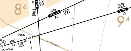
MTR - military training routes - grey/brown lines on chart ("IR-218" or "VR-218"). Only found on low altitude IFR enroute charts - not on high altitude.
Intersections
Represented as small triangles on LAEC. Large open arrow means use DME and number printed below airway to identify.
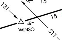
Arrow with kind of large open D around it includes total miles from VOR on radial for DME use. Small tip arrow (vs large open one) means you CANNOT use DME to find position fix (must use VOR radial).
Sometimes a localizer is used to identify an intersection.
Open triangle represents non-compulsory reporting point. Filled triangles are compulsory reporting points. If in radar coverage, do not need to report unless requested by ATC. If not in radar coverage, you must report so ATC knows where you are.
Position report:
- P - position
- T - time
- A - altitude
- T - type (IFR/VFR)
- E - ETA next fix
- N - next fix after that
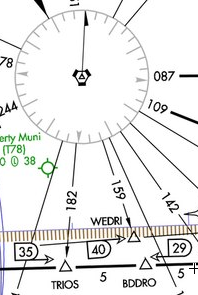
Change-Over Points
At changeover points tune in point in front of you and stop using one behind you. Three types:
1. Bend in airways
2. Looks like a square S - Number on top of changeover symbol is distance to next VORTAC, number on bottom is distance from previous VORTAC. Use DME to know when you reach it.
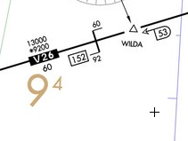
3. Halfway point of total distance (eg, 34 miles below)
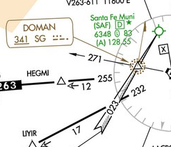
Altitudes
1. MEA - Minimum Enroute Altitude. Provides obstacle clearance and acceptable navigational signal coverage. T intersection / dinner plate symbol (shown below at SALON) indicates an altitude change (in this case, from 8,000 to 13,000). Lowest altitude for crossing a radio fix beyond which there is a higher MEA is the MEA at which fix is approached. Eg, if 4200 on one side and 4500 on other means 4200 over intersection then climb.
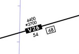
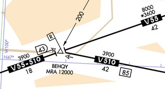
2. MOCA - Minimum Obstruction Clearance Altitude - The altitude in the image below the MEA with a * before it (*9200). A MOCA guarantees obstruction clearance, but does not guarantee navigational signal reception, except within 22 nm of a VOR (the only time ATC can assign it to you). It represents the absolute lowest altitude you should fly! A MOCA of 9200 is shown on V26 below.
3. MCA - Minimum Crossing Altitude - Represented by a flag with a X on it. Start your climb before the radio fix, MCA is the altitude at which you must leave the fix. A MCA is shown below at JESSY.
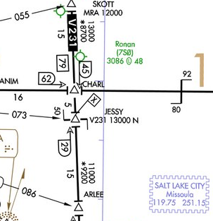
MCA info often found above info box for a VOR:
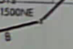
- "V95-160 12900 NE" - means if leaving on V95 to the northeast, MCA = 12,900
- "V95-421 12600 S" - if leaving on V95 to south, MCA = 12,600
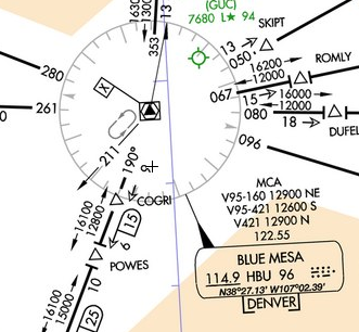
4. MRA - Minimum Reception Altitude - Depicted by flag with R on it. In order to get off-airways signals (from crossing VOR radials) must be at or above MRA. Open "D" looking thing next to radial will show distance to its VORTAC. Only time you must be at MRA is if you do not have DME and need to report an intersection, otherwise you can ignore.
Airports
Airport shown in green letters has instrument approach.
Airport shown in blue has instrument approaches for both civilian and military
Airport shown in brown - NO instrument approach
ARTCC
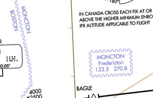
Represented by blue jagged line or postage stamp with the current ATC sector frequency:
Weather / FSS / Etc
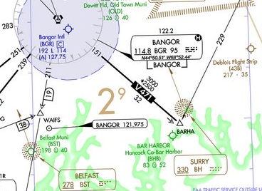
RCO - Remote Communication Outlet - Remote transmitter / receiver on which FSS can talk to pilots, notated by small unshaded rounded black box around it. Operated by FSS and NOT by ARTCC.
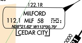
FSS - Flight Service Station - Notated by frequency above a VOR info box. The "R" after the frequency means FSS receives on that frequency, but they will transmit back to you over the VOR frequency.
H - HIWAS - Continuous broadcast of inflight weather advisories - SIGMETs, cSIGMETs, AIRMETs, AWWs, CWAs, and urgent PIREPs